Chile is a country of contrasts. Our configuration and length allow the existence of multiple colors and shapes from north to south; innumerable landscapes that go from the wonders of the high plateau to the exuberant vegetation of the Juan Fernández archipelago, passing through the dryness of the Atacama desert and the glaciers of the south. Each one of them determined by the existing climatic conditions.
The mere fact of having a length close to 4,300 kilometers in continental Chile benefits our country’s climatic wealth. Another factor that also comes into play is our position regarding the equator, which determines the distribution of light and temperatures, as well as the arrangement of the forms of relief, from north to south, which generate s real climatic screen (natural barrier that protects a determined area from the climatic influence that exists in the adjacent area).
We must also add the location of high and low pressure centers, which offer a great stability to the north of our country and a marked seasonality to the rest of the country, and the influence of the Pacific ocean, highlighting the presence of the cold Humboldt current.
If we perform a general classification of our country’s climates , we can state that there are three large climate zones. The northern zone is characterized for presenting desert and steppe climates, with scarce precipitation, while in the central zone and to the south, a temperate climate stands out, clearly seeing the succession of four seasons a year, as well as an increase in precipitation and a decrease in temperature from north to south. Finally, in the southern zone of our country we detect the existence of a rainy climate, characterized by its low temperatures.
Climates of Chile
According to the Meteorological Center of Chile, our country has 19 climatic varieties. Although each of them is located in a specific sector, we mustn’t forget that these locations are not exclusive, there can be traits of one climate beyond the mentioned regions and borders. Likewise, we must take into consideration that some climatic factors and phenomena can alter the configuration of some zones.
Next, we point out some features of our country’s main climates, analyzed from north to south.
– Desert with abundant clouds: located in the entire coastal area of the Arica and Parinacota, Iquique, Antofagasta and Atacama regions, it is characterized by its great stability. The variation between daily temperature extremes is minimal, as well as the one that exists between the months of winter and summer. It has scarce precipitation and a clear influence from the Pacific anticyclone, which determines a great dryness. Its main characteristic is the presence of great cloudiness (in the form of a mist called camanchaca) that usually shows up at night and begins to thin as the morning progresses.
– Normal desert: above 1,000 masl, we find this type of climate in the pampas aof the regions of Arica and Parinacota, Iquique and Antofagasta, whose main trait is its extreme dryness (due to the presence of a very stable and dry mass of air). Precipitation is nearly nonexistent, skies are clear year-round and thermal oscillation is quite high because the temperatures are pretty high during the day (they reach 18ºC on average), while at night hey can reach 0ºC.
– Altitude marginal desert: it is located from the region of Arica and Parinacota to the region of Coquimbo, between 2,000 and 3,000 masl, in the areas near the Andes mountain range. Although a dessert environment is predominant, there is a considerable increase in precipitation, mainly in summer (due to the high plateau winter). Temperatures decrease proportionally to the increase in altitude, with an average that does not surpass 10ºC.
– Low marginal dessert: it develops in most of the region of Atacama, to the north of the region of Coquimbo, before the Elqui valley. It presents modified desert characteristics, with a higher presence of precipitations, which increase from north to south according the location’s altitude. In the littoral area of the region of Coquimbo there is an increase in humidity due to the scarce presence of the Coastal mountain range.
– High steppe: we ocate this climatic variation above 3,000 masl in the regions of Arica and Parinacota, Iquique and Antofagasta. It is characterized for having quite cold temperatures and precipitation that decreases from north to south. The existence of masses of air loaded with humidity coming form the Amazon basin and the Atlantic explain the presence of precipitations in the northernmost sectors of our country.
– Steppe with abundant cloudiness: this climate is located on the entire coastal strip of the region of Coquimbo, whose main features are a considerable low morning cloudiness, low thermal amplitude and abundant precipitation during the winter months, which increase from north to south and due to the action of altitude.
– Steppe with great atmospheric dryness: inland in the region of Coquimbo, where the transverse valleys are found, we detect a higher presence of precipitation during winter, as well as scarce humidity. Climatic conditions allow this sector to present clear skies during most of the year, easing astronomical observation. – Warm temperate with a 7 to 8 month long dry season: this climatic variety develops from the interior of the south of the region of Coquimbo to the valleys of the region of Libertador Bernando O’Higgins, with considerable precipitation during the months of winter. During the other months, rains barely surpass 40 millimeters. In the coastal areas of the regions of Valparaiso and Libertador Bernando O’Higgins, similar conditions develop, only they have more cloudiness.
– Warm temperate with a 4 to 5 month dry season: made up by the Andean areas of the regions of Valparaiso, Metropolitana, of Libertador Bernando’Higgina and the entire surface of the Maule region and the northern strip of the region of Biobío, this climate is characterized by a longer period of rains and not exclusively in winter, many in the form of snow. Annual temperatures vary between 13° and 15°C and go down considerably at night. As we move south, taking up a great part of the region of Biobío and the northern and intermediate zone of the region of Araucanía, a climate predominates with similar characteristics, but with a dry season of less than fourth months.
– Rainy temperate with a Mediterranean influence: this climate is located in the southern coastal sector of the region of Biobío (province of Arauco), as well as the Araucanía area and in the regions of De los Ríos and De los Lagos, which presents an increase in rainfall from north to south, spread out throughout the year. It presents annual average temperatures that gradually drop and a thermo amplitude that is reduced as an effect of the sea.
– Cold temperate with an occidental coast and a maximum winter level of rain: it is a climate that takes up the southern sector of the region of Los Lagos and the island of Chiloe down to the Strait of Magellan. It presents intense precipitations, the rainiest period being the one that occurs between the months of May and August. In addition, the rains are associated to strong winds coming from the northeast and the north (especially in summer). Atmospheric humidity is high (over 80%) and although the temperatures drop with latitude, they are not so extreme due to the action of winds and the sea.
– Icy due to altitude: this climatic type is located in the high Andean peaks and the ice fields of Patagonia, whose main features are strong winds and very cold temperatures, many times below 0ºC. In these sectors, all types of precipitation are in the form of snow.
– Cold steppe: it presents itself in the trans Andean areas of Patagonia, spread out mainly in two zones: between 44 and 48 degrees southern latitude and in the continental and insular territories that border the Strait of Magellan. It is characterized for presenting low temperatures (with an average temperature of 6ºC) and abundant precipitation, that decreases towards the south. Records show that rains reach between 500 and 1,200 cubic millimeters a year.
–Tundra: it is located in the islands of our country’s far south, beginning at 51º latitude, south of the Strait of Magellan and Tierra del Fuego. It has abundant precipitation (the highest rates of the country), which show up as rain in summer and snow in winter.Temperatures are fairly homogenous, averaging between 5 and 7ºC. There is, therefore, a difference of only 4ºC between the hottest month and the coldest.
Chilean Antarctica and insular territory
The territories Chile has in both the Antarctic peninsula and the southern Pacific (Easter Island and Juan Fernandez Archipelago) have peculiar climates.
Antarctica is characterized for being the planet’s coldest continent and for having abundant precipitation in the form of snow. The Chilean Antarctic territory (which goes from 53 º and 90º longitude west of the south Pole) does not escape these extreme conditions, presenting annual average temperatures of -3ºC. Thermal amplitude is very low, reaching only 4ºC. it is also necessary to take into account that conditions vary between the end of the peninsula and the more inland areas, due to the influence of the Drake Sea.
Easter Island also has peculiar climatic conditions. Its climate is tropical rainy, with an annual average temperature of 20º C and precipitations that reach 1,000 mm3 a year. Although there is rain throughout the year, it is mainly concentrated between the months of April and June. Due to the influence of the sea, thermal amplitude is very low and humidity is abundant, reaching up to 80%.
Finally, we must point out that the climate of the Juan Fernandez Archipelago is similar to the warm temperate with a 4 to 5 month dry season. However, it is rainier, which determines the special conditions of the area and the development of an exuberant and unique vegetation.
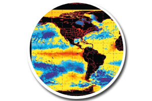
El Niño and La Niña: climatic alterations
Two important natural phenomena alter our country’s normal climatic conditions every now and then. The El Niño phenomenon is derived from the presence of the current of the same name in the waters of the Pacific ocean. It moves from north to south, parallel to the south American coast, carrying abnormally warm waters that not only affect our country every now and then, but also the south American and Oceanic coasts. The climatic effect that suffers the greatest disorders when faced with this phenomenon is precipitation, which become more abundant and intense.
In Chile there is an increase in temperature in the air of the northern area and an evident alteration of the marine fauna, which goes down considerably.
Regarding the La Niña phenomenon, it is the opposite process of the one just described, characterized by a noticeable drop in the temperature of the southern sector of the Pacific. These waters, upon becoming colder than normal, determine a drop in the temperature of our country’s northern coast and an important shortage of rain, mainly in the central area of the country, which on many occasions generates droughts and serious disorders in the affected regions’ economic activities.


 Nace Charles Chaplin