Relief
One of the main attributes of this region’s relief is the dislodgement of its territory.
The conjunction of the Nazca, Antarctic and South American plaques was produced in front of the Taitao peninsula. The first two moved eastwards and the latter, westwards. Consequently, the grounds lowered, which is evident in the fragmentation of the territory and in the existence of many islands formed once the sea invaded the sunken territories.
Likewise, the intense glacial activity during the Pleistocene period also determined the special local morphology. The Southern Ice Field is a footprint of this region’s glacial phenomena.
The Andes Ranges: likewise, as in the Region of Aisen, in Magallanes, these are known as the Patagonian Andes and are the zone’s most important relief. We can distinguish the Andes properly so, the archipelagic area and the Magellan pampas. Beyond the American territory, in Antarctica, there are also some forms of relief that indicate the extension of these mountain ranges.
-
The Andes Ranges: they are located eastwards the region and advancing southbound, they reach the proximities of the Muñoz Gamero peninsula. From the Magellan Strait, the Andes are found transversally.
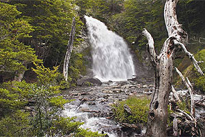
Some Andean glaciers stand out for their development. There is the Southern Patagonian Ice Field and the Tierra del Fuego south-eastern glaciered fields. The Andes most important summits rise above the 3.000 masl. The Fitz Roy mountain (3.406 masl) in one of them. -
The Archipelagic Area: is the zone where the Andes Ranges is dismembered and presents low height mountains. Their rock has mainly been sculptured by the ice and climatic conditions. Jointly with these hills, there are a large amount of channel, inlets, islands, peninsulas and gulfs, such as Trinidad, Ladrillero and Sarmiento. Among the archipelagos stand out Reina Adelaida and among the islands Madrede Dios, Tierra del Fuego and the Wellington Islands.
-
Magellan pampas: they belong to an extended area where the relief is undulated and spans north and southwards the Magellan Strait. In this zone there are great amounts of ancient maritime sediments. The ice exercised pressure upon them, lowering heights, forming lakes and leveling the coasts.
Hydrography
The relief, scarce precipitations and the weather of the western zone of the Region of Magallanes makes difficult the forming of hydrographical basins of large sizes. Thus, the rivers of this zone have little development.
Likewise, in the Territorio Antartico Chileno (Chilean Antarctic Territory) there are no surface water courses. The reason is the existence of the great ice mass covering most of its territory.
At the continental area, specially stands out the Serrano River basin (8.110 km2), water course located at the western sub Andean zone of Ultima Esperanza. Together with The Grey, Paine, Las Chinas rivers, the Serrano is a hydrographical system that waters the area located northwards the Manuel Señoret Ranges.
In the Region of Magallanes one may also find the Penitente and Grande rivers. The first is at the Province of Magallanes and the second at Tierra del Fuego. Both carry their waters towards Argentinean territory and constitute effluents of water courses of greater water flow.
Also can be mentioned the Perez river that is born at the Vidal ranges and runs a 40 km until mouthing in the Skyring inlet.
At the Brunswick peninsula are located the Canelos and San Juan rivers. The water of the latter comes from the Parrillar lake. Its estimated water flow is 30 m3/s and spans for 55 km. advancing until it mouths onto the Pacific Ocean southwards Fuerte Bulnes.
Another water course at the region is the Gallegos river, born from the junction of the Argentinean Turbio and Penitente river in Chile. The latter emerges from the slopes of the likewise named hill and receives waters from the Rubens river, its larger tributary.
The Gallegos river, advances for 172 km. crossing the Patagonian plateau until mouthing onto the Atlantic ocean. This is how the Gallegos river basin develops, mainly, in Argentinean territory, though in its middle course, receives waters from the Chilean Zurdo and Gallego Chico rivers.
Finally, the main hydrographical basin in Tierra del Fuego is the Grande river. This course of water is born from the junction of the Blanco and Ofhidro lakes.
Weather
The Region of Magallanes y de la Antartica Chilena has five main climates: cold template with great humidity, cold steppe, perpetual ice, tundra and polar.
– Cold template with great humidity: it develops at the western coast of the region and its main feature is to have low average temperatures (daily as well as annually), strong westwards winds, abundant cloudiness and high precipitation rates. For instance, in Bahia Felix the raining records are of 4.794 mm yearly.
– Cold steppe climate: it has low temperatures especially in winter. It happens at the Patagonian plains, which is an area where precipitations do not develop with the previously described intensity, though; they do fell permanently during the whole year.
– Perpetual ice climate: is found at the Southern Ice Field zone and at the glacial fields of the Darwin ranges. In this climate there is a predominance of solid precipitations, in other words, snow. Also the great variation of temperature between day and night (thermal amplitude) is another feature of this climate.
– Tundra climate: is located southwards the western lands of the region, from the Duque de York island. As the previous climates, it is characterized for its abundant precipitations, which develop through out the whole year. Also the law temperatures records are proper of this climate, for the thermometer does not overpass the 10°C in any of the 12 months of the year.
At the Evangelistas islands, where there is a predominance of this climate, the annual average temperature is 6, 4°C. And the precipitations average is 2..569 mm.
– Polar climate: it develops at the Territorio Chileno Antartico and their main features are low temperatures and abundant solid precipitations. Snow is even more abundant at the western coasts of the peninsula.
Regarding temperatures, the thermal annual average is below the 0°C. At the Southern Shetland islands, 2°C below cero are recorded and at Bahia Margarita (full Antarctic continent) the annual temperature average only reaches the 6°C below cero.