The Region of Tarapaca is located between the 18°56´ and the 21°36´ latitude south and from the 68°24´ longitude west until the Pacific ocean.. Limiting northwards with the Region de Arica y Parinacota, southwards with the Region de Antofagasta, and eastwards with Bolivia and westwards with the Pacific ocean.
Its surface reaches the 42.225, 8 km2, distributed in only two provinces: Iquique and Tamarugal.
Both have a total of seven communes: Iquique, Alto Hospicio, Pozo Almonte, Huara, Camiña, Colchane and Pica. Its regional capital is the city of Iquique, main economical motor of the zone, where is located the port of the same name and the most important free zone of South America.
In total, the population of this region reaches the 236.950 inhabitants. Out of which, most of them are men, reaching a 51,5% of the total of the zone. If we had to characterize the Region of Tarapaca population, we shall say that is concentrated in two great urban poles in the coastal zone, such as the city of Iquique and the locality Alto Hospicio. To the interior, the inhabitants are disperse, for which reason the regional density is 5,66 inhabitants by km2
Important mission
The creation of the Region XV demanded the restructuring of the Tarapaca region. For no one is a mystery that the differences between the coast and the inland is abysmal, having to face different problems and different economical developments. In the littoral is concentrated a great deal of the population in urban poles such as Iquique and Alto Hospicio. Advancing towards the Andes rangers, the population is scattered and evidently rural. Thus, it was considered the creation of a new province, the Tamarugal, which gathers the communities of Camiña, Colchane, Huara, Pica and Pozo Almonte, being the latter its provincial capital (congregating the 28,6% of the population of the Tamarugal).
Administrative division
The Region of Tarapaca is composed by:
-
Provincia de Iquique: its capital is Iquique
Is integrated by the communes of:
– Iquique: its surface reaches the 2.242,1 km2 and has 166.204 inhabitants
– Alto Hospicio: is the youngest commune, created in 2004. Its surface reaches the 593,2 km2 and has 50.215 inhabitants. -
Provincia del Tamarugal: has as provincial capital Pozo Almonte and is integrated by the following communes:
– Pozo Almonte: has a surface reaching the 13.765,8 km2 and a population of 10.830 persons (6.521 men and 4.309 women). Is the largest commune in the region and with a high percentage of urban population (66,5%).
– Pica: has a surface of 8.934,3 km2 and its population sums up to 6.178 inhabitants (4.569 men and 1.609 women). The percentage of the population inhabiting urban sectors in quite high, reaching the 75,6%.
– Huara: its surface is 10.474,6 km2 and its population reaches to 2.599 persons (1.499 men and 1.100 women). The totality of its inhabitants lives in rural sectors.
– Camiña: its surface is the smallest at regional level, reaching the 2.200,2 km2. It has a population of 1.275 inhabitants (676 men and 599 women) all living in rural zones.
– Colchane: its surface is of 4.015,6 km2 and its population reaches the 1.649 inhabitants. It has no urban population.
Relief
In the Region of Tarapaca is possible to distinguish the six forms of relief charactering our country. As it follows, you will find the particularity that in this zone adopts each one of them.
– Coastal shore and littoral plains: the Region of Tarapaca presents a narrow zone between the sea and the Coastal Ranges, originated by the erosion of the latter and that it does not reach more than two kilometers of width. Here is located the main urban and port centre of the region, Iquique. From this city to the river mouth of the Rio Loa (in the border between the Region of Tarapaca and the Region de Antofagasta), can be estimated a continuous littoral platform, with stretches with plenty amplitude allowing the longitudinal terrestrial traffic and the establishment of human productive activities.
– Coastal cliff: up to the north of Iquique is present as a solid rock mass, uprising from the deepness reaching the 800 masl.
– The Coastal Ranges: it possesses a scarce development in the region, presenting some isolated hills that reach only hundreds of meters and that develop from Punta Camarones until the Loa river.
– Intermediate depression: belongs to a space refill with products of different erosions and that was modeled by the wind and water action. Here is located the Pampa del Tamarugal, a plateau gong from the 600 up to the 1.500 masl and which names is due to the existence, c centuries ago, of a forest of tamarugos.
It is also the sector the rose economically during the XIX and XX centuries, since in its soils abounded the sodium nitrate better known as saltpeter.
– The Andes Ranges: in this sector it is present high and massif, with heights reaching the 6.000 masl. In the slopes of the western side it counts with some high plateaus, which are interrupted by deep creeks of a variable extension; in some cases, these latter ones are moved through by permanent water flows.
– High Plateau: is a plateau almost flat located between the western and eastern mountain chain of the Andes Ranges. It was formed thanks to the concavity present between both Andean mountain chains and that was filled with volcanic material and, afterwards was modeled by the action of the water flows of the zone.
Its average height reaches the 4.000masl coinciding the maximum summits with the volcanoes of the zone. There are some thermal water springs, such as Chusmiza, Puchuldiza and Mamiña springs.
Climate
While traversing the Region of Tarapaca is possible to differentiate four climatic zones corresponding to variations of the dessert climate. In the littoral, the temperatures are mild because of the effect of the sea, with little differentiated variations while, as we advance inland , we near the extremes conditions of the absolute dessert, where the at5hmospheric dryness is quite considerable and the daily thermal oscillations are quite ample.
Even though and accordingly with the latitude, the region of Tarapaca is located in a tropical zone and among its climatic characteristics we can find certain features differing from this type. The predominating climates are:
–Dessert climate: with abundant cloudiness located in the coastal sector of the region, this climate is characterized by the presence of cloudiness at night, which id dissipated in the morning hours. Precipitations are almost non existent and the daily thermal oscillation is minimal during the summer and winter months. The temperature is quite uniform during the year, with values from 18,7°C in July up to 22,3°C in February.
– Normal dessert climate: is typical of the interior zone, in plain pampa, at 1.000 masl. Characterized for presenting clear skies during the whole year and for the considerable daily thermal oscillation, with very high temperatures during the day and that at night may reach the O°C.
– Marginal altitudes dessert climate: over the 2.000masl in plain pre Ranges, the conditions become more unstable, including abundant precipitations during the summer, which allows de development of incipient vegetation. Temperatures are low, not surpassing 10°C.
– Altitude steppe climate: as off the 3.500masl, the average temperature does not overcome the 5°C, The relative humidity, in general, is low and there are precipitations of convective origin.
Hydrography
The climatic conditions and the soil characteristics are factors conditioning the scarce water availability of the region. In the high plateau, the existent water flows are of an endorreic character; the waters do not spring from the basin and are accumulated in lagoons and saltpans.
The lagoons are originated by the difficulty of draining the waters towards the Pacific, which accumulates during the summer months, by the high plateau climatic conditions above mentioned. The saltpans, meantime, are products of the percolation of salts from the Andes Ranges.
Also we must enhance waters of superficial draining, such as springs, that allow the fauna survival inhabiting the sector and the vegetation associations there located, such as wetlands.
Nearing the coast , is possible to find water courses with a brief development, as the ones present in creeks, which only occasionally reach the sea , others are lost in their way, as a result of vaporization. There are no rivers with a permanent course, except, southwards for the longest river of our country, the Rio Loa.
Biogeography
The flora as well as fauna in the Region of Tarapaca must undergo hard life conditions, from the lack of water up to the altitude problems, climate and soil salinity. But, in spite of locating us in the midst of the most arid dessert of the planet, life is born and flourishes, adapting and marvelling us for its variety. Thence, we can identify different ecosystems, conditioned by the different relief forms and their respective climates.
Thus, in the littoral, there are ecosystems proper of the coastal dessert, rich in vegetation and with an enormous flora species endemism that seizes the humidity coming from the low fog.
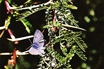
In the intermediate depression zone , the absolute dessert appears with its extremes conditions that characterizes it. In plain Pampa del Tamarugal, there are species such as the Tamarugo (Prosopis tamarugo), the Algarrobo Blanco (Prosopis alba), the Retorton (Prosopis stombulifera), the Grana salada(Distichilis spicata) and the Cachiyuyo (Atriplex spp.).. Also, there is a characteristic bird patrolling the sector, known as the Comesebo de los Tamarugos (Conirostrum tamarugense), which possesses a colourful plumage sorting out the extreme m conditions of its habitat.
Creeks as well as oasis are propitious environments for the development of some communities of vegetables and animals.
Both floras has been modified by the action of men; nevertheless, stands out bushes and herbs such as the Brea (Tessaria absinthioides), the Suncho (Bacharis juncea), the Cachina (Junctus acutus), the Sosa (Sacocornia fruticosa) and trees such as the Chañar (Geoffroea decorticans).
The high plateau is considered as the richest ecological area of the Region of Tarapaca. Located above the 4.000masl, it has humidity conditions allowing the flourishing of different species, among which are the Queñoa (Polypelis tarapacana), the Tola (Bacharis incarum) and Paja Brava (Festuca orthopylla).
At great height, we also find the Llaretal which main specie is the Llareta (Azorella compacta), which grows mainly in rocky surfaces. The dominating fauna of this sector is composed basically by rodents such as the Vizcacha (Lagidium viscacia).
Protected Wild Areas
For its importance and ecological value we can find two protected natural zones by CONAF (Forestry Nacional Corporation) in this region.
These are:
– Parque Nacional Volcano Isluga: located at 232 kilometres northwest of Iquique, in the Provincia del Tamarugal. Created the 3rd, January, 1967, it reaches 401.135 hectares and has a landscape characteristic of the high plateau (located at an average altitude of 4.000 masl). The local temperatures are extreme, normally oscillating between the 5°C and 10C but iot has been register, including -10°C.
The park is formed by plains and abrupt relieves, standing out the Alpajares, Quinsachatas, and Llanquipa hills, with altitudes soaring up the 5.000masl. Without any doubt, the most important summit is
Is the one given by the name of the park, the Volcan Isluga. This reaches a 5.530 masl and is characterized for presenting a snowy summit and with sporadic volcanic vents coming out from its crater.
There are also water resources giving more beauty to this sector, such as the Rio Arabilla and the Arabilla and Parintica lagoons.
A worthy sightseeing natural atraction is the geothermic camp Puchuldiza, composed by geysers and springs, in which the water reaches up to the 85° C. The volcanic vents are better seen al dawn. In winter, during the coldest months, waters freeze forming some ice blocks.
Besides, the park has an invaluable archaeological patrimony, among which we can find numerous vestiges of the pre Hispanic people that inhabited the zone, such as cemeteries, sectors used for funerary rites, pucaras and sanctuaries.
Part of the characteritic vegetation of this park are the species Duch as Chastudo(Oreocereus leucotrichus), the Guacaya (Corryocactus brevistyluys), the Paja Brava (Festuca ortophylla), the Llareta (Azorella compacta), and the Chachacona (Senecio nutans). The fauna is not a varied one; standing out the Llama (Lama glama), the Alpaca (Lama pacos), the Zorro culpeo (Pseudalopex culpaeus andinus) the Chilean Flamingo (Phoenicopterus chilensis), the Kiula (Tinamotis pentlandii), the Huairavo (Nycticorax nycticorax) and the Guallata (Phoenicopterus chuilensis).
– Reserva Nacional Pampa del Tamarugal: three territorial lots compose the Reserva Nacional Pampa del Tamarugal
Native forests and plantations of Tamarugo (Prosopis tamarugo) jointly with other species, give a break to the dryness of this sector. A forest in the midst of the most arid dessert of the world, that survives thanks to the existence of a phreatic aquifer of salty waters.
Created in 1987, it reaches a total surface of 100.650 hectares and is located in the community of Pozo almonte, at some 1.000masl. The Pampa del Tamarugal in located in the intermediate depression, protected by both ranges.
Its main attraction is, without doubt, the vegetation present in the region. There are plantations of tamarugos and algarrobos, which live together with species such as the Fortuna (Prosopis strombulifera), the Argentinean Tamarugo (Prosopis burkartii), the Grama salada (Distichlis spicata), the Retama (Cressa cretica), the Pillaya (Atriplex spp) and the Brea (Tessiaria absinthioides).
Given the lack of water the fauna in this sector is not abundant. There are only some rodents such as the Tuco tuco del Tamarugal (Ctenomys fulvus robustus), the Ratincito andino (Abrothrix olivaceus) and the Lauchon orejudo (Phyllotis darwini), mammals such as the Zorro chilla (Pseudalopex griseus), Culpeo (Pseudalopex cupaeus) and the Quique (Galictis cuja) and birds among which stands out the Lechuza blanca (Tyto alba), the Aguilucho (Buteo polysoma polysoma) and the Comsebo del Tamarugal (Conirostrum tamarugense).