Coast, sierra and jungle
Peru is bounded to the north by Ecuador and Colombia, to the east by Brazil, to the southeast by Bolivia, to the south by Chile and to the west by the Pacific Ocean. Its territory is divided from west to east into three distinct geographical regions: the coast, a long (2,480 km) and narrow dry plain (between 50 and 80 km wide); the Sierra, which is the Peruvian portion of the Andes that crosses the country from northeast to southeast, having three main divisions, the Western, Central and Eastern cordilleras. These shelter valleys and highlands, and have peaks surpassing 6,000 metres in height, such as Nevado de Huascaran (6,768 metres above sea level, the country’s highest peak). The Andes descend in eastern Peru to the third geographic area, a vast flatland covered by an enormous tropical rainforest. The river systems of this area are remarkably unified, all draining towards the Amazon basin (the Marañon-Huallaga and Ucayali Rivers). The Santa, Tumbes, Piura, Vitor, and Madre de Dios Rivers are other important rivers. Finally, the Lake Titicaca basin stands out, as it has the highest navigable lake in the world (3,808 metres above sea level), which Peru shares with Bolivia. Peru’s climate is determined by its latitude, topography and the cold Humboldt Current.
A growing economy
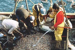
Although the tertiary (service) sector has gained importance in the Peruvian economy, agriculture, mining, industry, fishing and manufacturing remain relevant. This country’s exports consist primarily of raw materials, the main destinations being the United States and China. Thus, aside from being the world’s largest producer of fishmeal, it is also the world’s second largest producer of silver, tin and bismuth, third in zinc and tellurium, fourth in lead, fifth in copper, and in gold it takes the eighth place in world rankings.
Its main products are sugarcane, potatoes, rice, maize, cotton, coffee and wheat.
In 2005, the Peruvian economy grew by 6.67%, bringing its GDP to 165.7 billion dollars. It is estimated that this year the GDP should grow by around 7%.
From departments to regions
Peru is a presidential republic, governed by the Constitution ratified by a popular referendum in 1993.
Executive power is exercised by the president, elected by direct vote for a period of five years. Legislative power resides in the National Congress, which is unicameral and has 120 members. Judicial power is exercised by the Supreme Court.
For administrative purposes, the country is divided into 24 departments, 179 provinces and 1,828 districts. However, Peru is presently undergoing a process of regionalisation, by which the departments are intended to be replaced by 26 newly created regions.
A mestizo and indigenous population
The Peruvian population is made up of two main components: indigenous or Amerindian (mainly Quechua) and Mestizo. There is a smaller percentage of European descent or part of other minority groups, such as Afro-Peruvians and Asians (known as Nikkei or Japanese descendants and Tusán or Chinese descendants).
According to the figures provided by the 2005 census, the population of this country is more than 27 million, of which 73% is urban and 27% is rural. The main cities are: Piura, Chiclayo, Trujillo, Chimbote, Lima and Arequipa.


 Termina la Guerra de Corea