In order for a zone in our country to acquire the denomination national reserve, it must specifically be an area whose natural resources must be conserved used with special care, due to their susceptibility to degradation or their relevant importance in safeguarding the community’s wellbeing.
Unlike parks, it is possible to use the resources of national reserves (like water or soil for example) in a sustainable way, safeguarding the conservation of the different ecosystems dynamics.
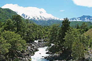
Our country has a total of 48 national reserves, and they are:
Northern zone
– Las Vicuñas: it is the reserve located farthest to the north in our country and belongs to the commune of Putre. It is characterized for having vegetation that is typical to the area, with wetlands, Polylepis rugulosa and tolares, among other species, as well as by the presence of a few aimara communities that inhabit the area.
– Pampa del Tamarugal: located in the region of Tarapaca, its main characteristic is being the habitat of the tamarugo forest, which is located in one of the planet’s driest zones, in the middle of the Atacama desert.
– La Chimba: 11 kilometers from Antofagasta, it is a protection area that safeguards our country’s coastal desert’s characteristic flora and fauna.
– Los Flamencos: inserted within the Andean pre mountain range in the region of Antofagasta, it has numerous sites of great scenic beauty, like the Tara saltpan, Pujsa saltpan, Miscanti and Miñiques lagoons, the Atacama saltpan and the Valle de la Luna (moon valley).
– Las Chinchillas: located in the commune of Illapel (Region of Coquimbo), this reserve protects one of the last natural environments of the Long-tailed Chinchilla (Chinchilla lanigera).
– Humboldt Penguin: this reserve is located right on the border of the regions of Atacama and Coquimbo, and it is made up of three islands: Damos, Choros and Chañaral de Aceituno. Important colonies of penguins and bottle-nosed dolphins inhabit these islands, among other species.
Central zone
– Blanco river: with a surface of 10,175 hectares, it belongs to the commune of Los Andes, in the region of Valparaiso.
– Peñuelas lake: its name comes from the artificial dam created at the beginning of the XX century to supply water to some sectors of Viña del Mar and Valparaiso. Today, it has become an excellent spot for the observation of birds, fishing and recreation.
– El Yali: it takes up 520, 37 hectares and its creation is linked to the conservation of species, especially birds, that live in one of the few coastal wetlands on the planet.
– Clarillo river: located in the pre mountain range of the region Metropolitana, it takes up 13,185 hectares. It is located in the rio Clarillo banks, with numerous gullies and natural pits formed amongst the rockeries.
– Rio de los Cipreses: with Los Cipreses river as its main bed, this reserve is the habitat of a few endemic species with conservation problems like the Burrowing Parakeet (Cyanoliseus patagonus) and the Cordilleran Cypress (Austrocedrus chilensis).
– Cobre de Loncha Oakery: declared a reserve in 1996, it has a great number of endemic species, like the Hualo (Nothofagus glauca) and the Chilean Wine Palm (Jubaea chilensis). In addition, is houses diverse varieties of birds, like quails, diucas, loicas, tordos y zorzales, entre otras.
– Federico Albert: it takes up 145 hectares located in the commune of Chanco, region of el Maule. Its main characteristic is its vegetation, made up by eucalyptuses, pines and cypress trees, which were planted to stop the advancement of the coastal dunes.
– Torca Lagoon: it was created in 1996 in the region of el Maule. Its flora is made up of, in its majority, by introduced species, like Radiata Pine (Pinus radiata) and Eucalyptus (Eucalyptus sp.). It is the habitat of many birds and fish, with standouts like black-necked swans and coscoroba swans, and fish like carp, gambusia and chelons.
– Los Ruiles: located in the Coastal mountain range of the region of el Male, this reserve was created in 1982 and has 45 hectares. Its main objective is safeguarding one of the zone’s native trees, the Ruil (Nothofagus alessandrii).
– Los Bellotos del Melado: this reserve is in the pre mountain range of Linares and has 417 hectares. It is one of the environments where the Southern Belloto (Beilschmiedia berteroana) lives.
– Los Queules: it is located 71 kilometers from Cauquenes (also in the region of el Maule) and was created in 1995. Its main objective is the protection of an Endangered endemic plant species, the Keule (Gomortega keule).
– Altos de Lircay: it is located 66 kilometers east of Talca. Located in the pre mountain range and mountainous sectors of the region of el Maule, it borders the north bank of the Lircay river. It was created in 1996 and covers 12,163 hectares.
– Radal Siete Tazas: this sector, located in the commune of Molina, has been considered a national reserve since 1996. It presents a representative vegetation of deciduous forest, with species like oaks, peumos and hualos.
– Ñuble: created in 1978, it reaches an extension of 55,948 hectares. It constitutes the habitat for the last populations of South Andean Deer that develop farther north than their normal lands of distribution.
– Mocha Island: it corresponds to a land located in front of the shores of the region of Biobio. It has been catalogued as a reserve since 1988 because it is considered one of the lest intervened environments worldwide.
– Los Huemules de Niblinto: with a surface of 2,021 hectares located in the commune of Coihueco (region of Biobio), its main objective is to preserve one of the last populations of South Andean Deer that inhabits central Chile.
– Ralco: it is located in the Andean mountain range of the region of Biobio and has a surface of 12,492 hectares, in which there is an interesting development of biodiversity, made up plantwise by lenga beeches, Antarctic beeches and araucarias, and animalwise by black woodpeckers and condors.
Southern zone
– Alto Biobio: located in the region of la Araucania, it has an extension of 35,000 hectares. The Biobio river is born is born from the west bank of the Galletue lagoon, located in this zone.
– China Muerta: it is made up of 9,887 hectares and was created in 1968. It borders Conguillio National Park and houses one of the best conserved araucaria forests.
– Malalcahuello: located in the province of Malleco, it was created in 1931. From that date on, it has seen its original surface reduced, currently reaching 13,730 hectares. Its flora and fauna differ depending on location, be it in the lower part of the Andean mountain range, or in higher terrain.
– Nalcas: created in 1967, it has a surface of 13,775 hectares. It is in the province of Malleco, region of la Araucania, and has a landscape that has been highly altered by the eruptions of Lonquimay and Tolhuaca volcanoes.
– Malleco: it is our country’s first protected wild area, created in 1907 with the objective of regulating the commerce of wood and preserving plant species. It includes one of the country’s most important native forests within its 16,625 hectares.
– Villarrica: located in the province of Cautin, region of la Araucania, it was created in 1912 and has 60,005 hectares. Its main attraction are the snow-covered peaks of Sollipulli, where there is a glacier that is 12 kilometers long.
– Valdivia: created in 1983, it constitutes a zone of high ecological and scientific value, because it houses populations of Patagonian Cypress and evergreen forests in excellent conservation conditions.
– Mocho-Choshuenco: located 60 kilometers from Panguipulli, in the region of los Rios, this reserve owes its name to the volcanoes that are a part of it: Mocho and Choshuenco. In addition, it has a glacier located in the volcanic slopes and a Valdivian type forest.
– Palena Lake: located in the region of los Lagos, it has 49,415 hectares. It is found near the border with Argentina, country with whom it shares the water of lake Palena (which receives the name of General Vintter on the other side of the montains), the first bi-national lake. It also has a lenga beech forest that goes from the high peaks to the foot of the lake.
– Llanquihue: its surface (33,972 hectares) is located in the province of the same name, in the region of los Lagos. Among its main natural beauties are lake Chapo, Petrohue river and Calbuco volcano.
– Futaleufu: located in the province of Palena, region of los Lagos, it covers 12,065 hectares, in which mainly two species are safeguarded: the South Andean Deer (Hipocalemus bisulcus) and the Cordilleran Cypress (Austrocedrus chilensis).
– Castillo Hill: it is found south of Coyhaique, in the region of Aysen, and it takes up a total surface of 134,000 hectares. In it, there are native forests of lenga beech and Conde rock, which is a rock formation molded by natural factors that is similar to a human profile.
– Coyhaique: it was created in 1948, has a surface of 2,150 hectares and belongs to the commune of the same name. Its great biodiversity stands out, having forests of coihues, lenga beeches and Antarctic beeches and animals like pumas, red foxes and small parrots.
– Carlota Lake: created in 1965, it is located in the commune of Lago Verde, in the region of Aysen. It has great attractions, like lake Carlota, the mountainous chord of Caceres hill and the great variety of animals that live there (wild boars, flamingos, black-necked swans and south Andean deer, among others).
– Katalalixar: located northeast of Tortel cove, in the region of Aysen, it has a surface of 674,500 hectares. Within them, it is possible to find important stretches of native forest, with predominant species like the Pilgerodendron (Pilgerodendron uviferum) and the Mañio (Podocarpus saligna).
– Cochrane Lake: it has a surface of 6,925 hectares and is located 350 kilometers south of Coyhaique, on the slopes of Tamango hill, next to lake and river Cochrane.
– Las Torres Lake: located in the region of Aysen, it takes up a surface of 16,516 hectares, which house important species, like tepas, tineos and mañios.
– Jeinimeni Lake: with a total extension of 161,000 hectares, this reserve is located in the region of Aysen, south of Chile Chico (little Chile). Its main attractions are the lake that gives it its name, of turquoise waters, and a cave with cave paintings made by the tehuelches that used to inhabit the zone.
– Trapanada: created in 1992, the reserve has 2,305 hectares. It is located 45 kilometers from Coyhaique and the Aysen decisuous forest is predominant in the sector, whose main attraction is the Lenga Beech (Nothofagus pumilio).
– Rosselot Lake: it belongs to the commune of Cisnes, in the region of Aysen and takes up 12,725 hectares.
It was reclassified as a reserve in 1983 (before, it was dubbed a national park) and its main attraction is the lake of the same name.
– Las Guaitecas: created in 1938, it is one of the country’s oldest wild areas. It has 1,097,975 hectares, including part of the Chonos and Guaitecas archipelagos.
– Simpson River: taking its name from the river that goes through its 40,452 hectares, this reserve has forests of coihues, tepas and mañios. In addition, it constitutes the habitat of south Andean deer and pumas.
– Alacalufes: located south of the Magellan straight, it is characterized for being a zone that has numerous canals and fiords, spanning all of the western archipelagos of the Ultima Esperanza province. Its total surface reaches 2,313,875 hectares and its varied marine fauna stands out, where there is an abundance of sea lions and whales.
– Parrillar Lagoon: it is 52 kilometers away from the city of Punta Arenas and has 18,414 hectares. A highlight is the lagoon that lends its name to the reserve, which is covered by ice during periods of low temperature.
– Magallanes: it has a surface of 19,625 hectares, from where it is possible to see the cit of Punta Arenas, the Magellan straight and the Seno Otway.


 Muere Evita