Four relief forms clearly stand out from the coastal zone to the Andes Ranges in this region.
– Littoral plains: they develop greatly, with an average width near the 25 km. This is due to the fact that the Coastal Range is quite distant from the sea.
– Coastal Range: at the region’s northern part has, more or less, the same conformation of the region of O’Higgins but with heights that almost exceed the 800 masl. Some of the most important summits are: Name (810 masl), Ninguni (807masl), Caiquen (725 masl), Ranchones (574 masl) Altos Los Cruceros (553 masl), Sal Si Puedes (548 masl) and Mocho (348 masl). At the Maule river southern sector this range raises again dividing itself in several mountain ranges advancing parallel wise, leaving amongst them valleys with microclimates and apt soils for agriculture.
– Intermediate depression: is narrow in the region’s northern part though it widens as it advances southwards. For instance, in Molina reaches an average width of 20 km whilst at Linares is 42 km. Although flat in some sectors, generally, is a plain slightly undulated.
– The Andes Ranges: the pre range zone has a sedimentary origin and 429 km length and a width varying from 30 to 45 km. Also, there are elevations fluctuating between the 300 and 850 masl. Is a territory with a difficult topography because of its abrupt slopes and narrow rivers.
Meanwhile, the Andes Range’s area is lower than in the Region of O’Higgins and its average height slightly exceeds the 4000 masl. The main volcanoes are: Peteroa (4.090 masl) Planchon (3.9777 masl), Descabezado Grande (3.830 masl), Cerro Azul (3.810 masl) Descabezado Chico (3.250 masl) and Quizapu (3.050 masl).
Hydrograph, nivopluvial nurturing
The river nurturing in this region has a nivopluvial pattern but rains become more important due to the decrease of the Andes Ranges heights, which produces a minor snow accumulation. The two main water systems are the Mataquito and Maule rivers.
–The Mataquito river: its hydrographical basin has 6.200 km2 and is originated at 12 km westwards Curico, from the junction of the Teno (which is born of the junction of the Malo and Nacimiento rivers) and Lontue rivers (the latter is formed from the junction of the Los Patos de San Pedro and Colorado rivers and other brooks such as the Upeo and the Potrero Grande).
Alter drifting 95 km, the Mataquito flows near the Iloca beach resort.
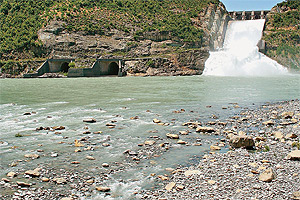
– The Maule river: its basin is much larger than Mataquito´s since it covers about 20.600 km2. Its river bed has an average flow of 544 m3/s, but during July can exceed the 2.000 m3/s.
Is born at the likewise named lagoon that is located at the ranges at 2.2000masl near the Pehuenche international path.
Other rivers contribute to its coastward progress, such as the Puelche, Colorado, Cipreses and Melado. After this is restrained at Colbún.
Farther below, at the intermediate depression, the Maule river takes the contribution of the Claro and Loncomilla rivers and the Los Puercos brook at its lower river bed. After drifting for almost 250 km it flows into the ocean near the city of Constitucion.


 Muere Evita