Located fully at the country’s central zone, the Region of the General Liberator Bernardo O’Higgins is located at 33° 51´and 35°01´latitude south and between the 70°02 longitude west and the Pacific Ocean. It limits northwards with the Valparaiso Region and the Metropolitan Region, southwards with the Maule Region, eastwards with Argentina and westwards with the Pacific Ocean.
Its surface is of 16.387 km2 which constitutes the 2, 17% of American and Islander Chile. Its regional capital is the city of Rancagua and, totally, has three provinces and 33 comunas (counties).
According to the 2002 census, its population reaches the 780.627 inhabitants, representing the 5, 16% of the country’s total.
At the coastal zone there are several disperse urban centers such as Pichilemu, Lolol and Marchihue, while, at the full intermediate depression , besides the already named places, small villages are located such as Graneros, San Vicente of Tagua Tagua, Rengo, San Fernando and Chimbarongo. In most of them still endure the peasant tradition.
Administrative organization.
The Region of O’Higgins is divided into three provinces.
These are:
– Province of Cachapoal: is the largest in surface, with 7.4384 km2 and have a total of 542.901 inhabitants, according to the data provided by the 2002 Census. Out of which, 415.108 persons live in urban areas and only 127.793 live in rural sectors. Is made up by the comunas (counties) of Rancagua, Codegua, Coinco, Coltauco, Doñihue, Graneros, Las cabras, Machali, Malloa, Mostazal, Olicvar, Peumo, Pichidegua, Quinta de Tilcoco, Rengo, Requinoa and San Vicente.
Rancagua is the city with the largest quantity of inhabitants (214.344, out of which 109.465 are women and 104.879 are men.) being the capital of the region. Its surface reaches 260, 3 km2, sheltering the 27, 5% of the regional total population. Machali is the comuna (county) with the largest surface at regional level, reaching 2.586 km2 while the smallest sized one is Olivar with only 44, 6 km2.
– Province of Cardenal Caro:it has a total surface of 3.324 km2 and 41.160 inhabitants. Is composed of the following comunas (counties): Pichilemu, La Estrella, Liteuche, Marchigue, Navidad and Paredones. Pichilemu is the one with the largest surface (749, 1 km2) and the one that has the greatest amount of inhabitants (12.392) while the one that shelters the largest amount of people is La Estrella with only 4.221. The smallest (300, 4 km2) is Navidad and the one with more inhabitants in rural zones.
– Province of Colchagua: its surface is of 5.678 km2 living in it a total of 196.566 inhabitants. Is made of the comunas (counties) of San Fernando, Chepica, Chimbarongo, Lolol, Nancagua, Palmilla, Peralillo, Placilla, Pumanque and Santa Cruz.
The one with the largest surface (2.441, 3 km2) and the most populated one (67.732 inhabitants) is San Fernando, whilst the smallest is Nancagua (111, 3 km2) and the less populated is Pumanque 83.4442 inhabitants), besides, the latter only has inhabitants in rural zones.
Relief
Is possible to distinguish the four forms of our country’s relief. As it follows, we shall indicate you their main characteristics in this zone.
– Littoral plains: in this region reaches a considerable development and its extension stretches between the 25 and 30 km. In Bucalemu and Pichilemu is possible to distinguish the development of terraces of even up to three levels while in the whole coast alternate accumulations of sand, beaches and cliffs.
– Coastal Ranges: it decreases in size and, even, has smooth undulations in its western slope. It does not exceed the 800 meters height and southwards the Cachapoal river decreases considerably, with the exception of Pangalillo hill which reaches 1.193 masl.
– Intermediate depression: is possible to differentiate two areas in it. The first is located at the region’s northern zone and is identified as the Rancagua basin. It embraces almost 60 km southbound and, as an average, it has a width of 30 km.
From the Pelequen Narrowing, the intermediate depression develop thoroughly, appearing very narrow in its beginning, slightly undulated and widening as it augments in latitude, transgressing the regional boundary.
– The Andes Ranges: it reaches an approximately width of 50 km and heights above the 4.000 masl. The main summits are the Picos del Barroso hill (5.135 masl), the Palomo volcano (4.860 masl), the Morro del Atravieso (4.590 masl), the Morro Piuquenes (4.393 masl) and the Tinguiririca Volano (4.280masl).
Hydrography
In this region, there are three most important river courses, which are:
– The Rapel river: is the zone’s most important basin, reaching 14.800 km2 in almost a trail of 70 km. Is born at La Junta sector, from the junction of the Cachapoal and Tinguiririca rivers. In its path does not receive important contributions besides the Alhué brook, which is born at the Metropolitan region.
In this river is located the Rapel reservoir with a storage capacity of 433 million cubic meters, which is used for agricultural labours and the development of tourism and sport activities. Finally, the Rapel river flows on the sea at the level of Navidad.
– The Cachapoal river: is born at Los Piuquenes hill and its basin embraces 6.400 km2. Among its tributaries are the Las Leñas river, the Cipresitos brook, the Cortaderal and Los Cipreses rivers; the latter one is born at the Reserva Nacional likewise named.
When the Cachapoal transits the intermediate depression passes near Rancagua city and receives the Claro river and the Zamorano brook.
– The Tinguiririca river: is originated near Las Damas pass at 3.050 masl, after the junction of the likewise named river and the Azufre river, Its basin contains 4.730 km2 at the region’s southern sector, receiving, near Cunaco, the Chimbarongo marsh.
Climate
In this zone prevails a landlocked climate with a long dry season, even though rainfalls are more abundant compared with more northern regions.
Is possible to distinguish three climatic varieties, depending of diverse factors as cloudiness, humidity, rainfall, etc.
– Warm template climate with winter rains, long dry season and great cloudiness: it prevails at the region’s littoral plains where conditions are stable. The daily and annual thermal magnitude is rather moderate, precipitations oscillate between 500 and 1.000 mm yearly (concentrating between May and August) and presents a high cloudiness.
– Warm, template climate with winter rainfalls and long dry season: is developed at the full intermediate depression. The annual thermal magnitude overreaches the 13°C, while there is a clear increase of precipitations in a southbound trail.
– Template climate of mountain degradation: is developed at the Andean Ranges, between the 600 and 4.000 masl. Is characterized for indicating temperatures below cero during the winter season and for presenting snow precipitations which increase from700 mm to 1.500 mm yearly.
Biogeography
The presence of a greater humidity and precipitations allow the existence of new environments in this region.
Thus, in the high Andean zone develops a hydrophilic steppe in which prevail undersized forests and bushes.
Here is possible to find some species adapted to the raise of precipitations and snow duration, such as the White Grass (Chuquiraga oppositifolia), the Chaurilla ( Pernettya pumila) and the Llareta (Azorella madreporica), among others.
As off this region also develops the deciduous kind of mountain forest that reaches up to the north of the Biobio Region. There are, in this zone, species such as the Andean Cypress ( Austrocedrus chilensis), the Oak Tree (Nothofagus obliqua), the Maqui (Aristotelia chilensis), the Litre (Lithraea caustica), the Hazel (Gevuina avellana) and the Southern Beech (Nothofagus dombeyi).
Descending from the heights of the Andean ranges slopes, there are native species that have undergone important alterations since great part of this zone’s soil has been used in agricultural or industrial labours, or for the settlement of population. Stands out the Peumo (Cryptocarya alba), the Maitén (Maytennus boaria), the Cinnamon (Drymis winteri) and the Burret (Luma chequen). The fauna is intergrated by such animals as the Brush-Tailed Rat (Octodon degus), the Long-Haired Laucha (Abrothrix longipilis), the Llaca (Thylamis elegans), the long-Tailed Bat (Tadarido brasiliensis), the Wildcat (Lynchaulurus colocolo) and the Patagonian Fox (Pseudalopex culpaeus).
The skies are controlled by birds such as the Condor (Vultur Gryphus), the Tricahue Parrot (Cyanoliseus patagonus) and the Loica (Sturnella loyca). Finally, in the littoral fringe, specifically at the coastal ranges western slopes, we can find the coastal Hard-Leaves Bushy forest, prevailing species such as the Espino (Acacia cavens), the Boldo (Peumus boldus), the Plantain (Planttago hispidula) and the Sigh (Nolana paradoxa). The living fauna in this sector is also abundant and composed by the Hare (Lepus capensis), Red Bat (Masiurus borealis), the Olive-Coloured Mouse (Abrothrix olivaceus) and the Southern Beaver (Myocastor coypus); among the birds are the Harrier (Buteo polyosoma), the Peuco (Parabuteo unicinctus), the Patridge (Nothoprocta perdicaria), the Chilean Swallow (Tachycineta leucopyga) the Thrush (Turdus falklandii), the Chirihue (Sicalis luteola), the Chincol (Zonotrichia capensis) and the Throstle (Curaeus curaeus), among others.
Protected wild areas.
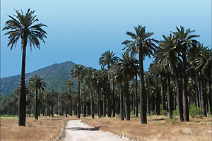
– The Cocalan Palm Grove National Park: is located in the Las Cabras comuna (county) between the 34°09´and 34°16´latitude south and the 71°04´and 71°14´longitude west. It has 3.709 hectares and is a private property.
It was created in 1972. Is the smallest in the country and its main feature is that has a considerable amount of samples of the Chilean Palm (Jubaea chilensis), being the most important Palm grove in the country, followed by the Ocoa, in the Valparaiso region.
– The Cipreses River National Reserve: was created in 1985 and is located at 50 km from Rancagua city, at the pre Andean ranges and the Andes Ranges.
It belongs to the Machali comuna (county) and comprises almost all the basin of the likewise named river. It has an extension of 36.882 hectares and shelters an important Andean population of Guanacos, one of the few remaining in the central zone. Also, is possible to find colonies of Tricahue parrots, Condors, Eagles, Stream Ducks and Magellan Wild Geese among others.
Another attraction of this reservation is the archeological remains of this zone’s first inhabitants, as well as, petroglyphs and ancient buildings.


