The lakes, saltpans and lagoons existing in the region are formed by the stagnation of the rains that fall during the summer in the high plateau.
Likewise, the climatic conditions, as well as the soil characteristics, do not allow a development and the constant dripping of important water flows.
In the high plateau are the Caquena and Lauca river, which waters flow into Bolivian territory. Also, in this same one, the Cotacotani lagoons have as affluents the Benedicto morales river and the El Encuentro brook.
In the sector of the Tarapaca Plateau (intermediate depression) the Lluta river and some water flows are developed going through the Camarones, Vitor y Azapa Creek that, occasionally, reach the sea. These small rivers have permitted the practice of agriculture in the oasis, which consists, mainly in legume, citric and olives cultivation.
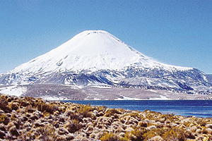
Lake Chungara
Is located at 196 km from Arica, within the Lauca national park. Located at 4.517 masl and has a surface of 21,5 km2.
It is surrounded by the Nevados de Payachatas (Parinacota and Pomerape volcanoes). Among its fauna we can find mammals such as vizcachas, alpacas, llamas and vicuñas.
There is also a great variety of birds, among which we can find, puna duck s, giant taguas and small and big flamingoes.


 Muere Evita