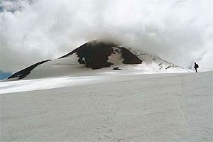
Organized westbound, in this land stands out the presence of the four relief forms of our country: the Andes Ranges, intermediate depression, the Coastal ranges and littoral plains.
– The Andes Ranges: it stretches from the Quetrupillan volcano (2.009 masl) until the Piramidal hill (1.744 masl). The mountains forming this range have smooth slopes and their origin come from volcanic processes happened during the Tertiary geological period.
Considerably lower at the northern regions, in the region of los Rios, the Andean ranges almost does not surpass the 2.000 masl. One of the main exceptions in the summit of the Lanin volcano, which peak is at 3.717 masl.
The abundance of volcanic cones is another feature of the Andean Ranges in this part of Chile. According to height, stands out the Mocho (2.415 masl), Choshuenco (2.422 masl), Puyehue (2.240 masl) and Quetrupillan (2.009 masl) volcanos.
-Intermediate depression: its soils were originated by glacial and river sediments. Also is called longitudinal valley and differently of other northern regions, it presents a narrow and discontinuous plain at the region’s northern zone. The reason for this circumstance is the inland expansion of the Coastal ranges.
– Coastal ranges: at the region’s northern zone shows higher and well formed. Likewise, it develops transversally, connecting with the Andes Ranges through mountain ranges called the Quele, Polcura and Mahuiddanche ranges. They are low hills which summits do not surpass the thousands meters, reaching around the 800 meters.
Farther south, the Coastal Ranges expands invading intermediate depression’s territories. It does this through the ranges that form the san José de la Mariquina depression.
As the Coastal ranges near the Valdivia river, it looses height towering only up to 6’00 masl. And is well known as the Pelada and Sarao ranges between the Valdivia and Maullin rivers.
-Littoral plains: it has a poor and discontinuous development at the region of los Rios. As off the Mahuiddanchi ranges dos not develop at all and there are some scarce narrow spaces at the Valdivia and Bueno estuaries.
Hydrography
There are two important hydrographic basins at the region of los Rios: the Valdivia river basin and the Rio Bueno basin. Both water flows are sailable and have a rain nurturing regime and stretch out for 200 and 130 km, respectively.
The Rio Bueno as well as the Valdivia river run westbound and flow onto the Pacific Ocean. The Valdivia river flows onto the Ocean at the Corral Bay and the Bueno at the Dehui Point. The Valdivia river’s hydrographic basin comprehends 11.056 km2 and is composed of the san José, Cruces, Calle Calle and San Pedro rivers. This latter course receives the waters from the Riñihue lake and through this, of the Calafquen, Pangupuloli and Pirihueico lakes, besides the Argentinean Lacar lake.
The Valdivia River’s medium flow volume at the height of its mouth is calculated between the 600 and 1.00 m3/s. The Bueno River has a hydrographic basin of 15.124 km2 and its main effluents are the Pilmaiquen and Rahue rivers. The first drains the Puyehue Lake and the second drains the Rupanco Lake. Its medium flow volume at the height of the Rio Bueno comuna (county) is of 373 m3/s.
Climate
The Region of los Rios is a humid ambiance with precipitations every month of the year. Besides, the temperatures diminishes making the environment colder; although in almost all the region the lowest monthly average temperature does not lower the 6°C.
For its short extension, seemingly, the Region of los Rios is a homogenous territory, regarding the climate, though; it really presents climatic variations surging from the local orographic characteristics. Thus, the following climate types can be distinguished:
-Rainy template with landlocked influence: it develops at the region’s central and western territories. The average annual temperatures vary between the 9°C and the 12°C, thou, in summer, at localities placed in the intermediate depression, they tend to increase.
Precipitations vary from 1.800 to 2.500 mm annually and though the summer months are less rainy, this climate does not present dry seasons..
At Valdivia, the rainy template climate with landlocked influence has an average temperature of 11, 9°C due to the influence of rivers and the Ocean. In summer, the temperature can reach 17°C and in winter it may descend to 7, 7°C. Precipitations can reach 2.536 mm yearly, being July the most rainy month with near 429 mm.
– Warm Rainy template with summer precipitations decrease: it is present at the Coastal ranges leeward zones such as san José de la Mariquina and Rio Bueno. At these places the annual precipitations reach levels of 2.000 and 1.235 mm, respectively. The annual average temperature varies between the 10°C and 12°C and in summer the average is 16°C.
– Cold rainy Template or mountainous: it develops at the Andes Ranges above the 500 masl and presents precipitations as rain and snow with annual levels between the 2.500 and the 4.000 mm. The annual average temperature goes from 9°C to 6°C. In winter, the thermometer can indicate very near the 0°C and in summer the monthly average may fluctuate between the 10°C and the 15°C.


 Muere Evita