The modeling of the relief of Aisen has been the product of the combined action of a tectonic sinking, intense glacial and volcanic activity, adding up some other agents such as precipitations (snow and rain), wind and the sea nearness. In this so particular physiognomy, the following relief units can be found:
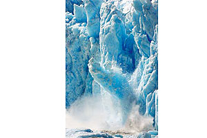
– Andes Ranges: in this region is called the Patagonian Andes and are the most important and the biggest relief unit. It develops in a continental and islander form and is characterized for having an abrupt topography (with great unevenness and narrow passes) and for having scarce intermountain plains. Nevertheless, its main feature is the extended ice fields, which cover a great part of the ranges western sector, forming the Northern Ice Field. This is front wise the Tres Montes peninsula; it has a 4.400 km2 surface and great drifts: San Rafael, San Quintin and Steffen. Also is the Southern Ice Field which is shared with the Region of Magallanes and has a larger extension than the Northern Ice Field and from which dislodges the Jorge Montt drift.
The greatest heights of the Patagonian Andes are the San Valentin or San Clemente summits with 4.058 masl, the Cochrane or San Lorenzo mountain with 3.058 masl; the Fitz Roy mountain with 3.406 masl; the Lautaro Volcano with 3.380 masl; the Hyades hill (3.078 masl), the Maca volcano (2.690 masl), the O´Higgins volcano (2.910 masl), the Baker hill (2.600 masl) and the Hudson volcano with 2.600 masl.
Towards the western sector, the range descends joining the Patagonian high plateau presenting the most adequate places for human settlement.
Southwards the Golfo de Penas, the range breaks into different islands grouped onto archipelagos forming channels, fiords and straits.
– Intermediate depression: it appears eastwards the Taitao peninsula until the Istmo de Ofqui, disappearing definitively at the Golfo de Penas.
In this region, the intermediate depression is under the sea because in glacial times it received large and heavy ice masses that produced its sinking.
Later, as the global temperature rose (nearing the actual temperatures), these ice masses thawed away leaving submerged valleys and giving birth to gulfs and channels.
– Coastal ranges: it appears as a fragmented fringe and develops between the Archipelago of the Chonos and the Tres Montes point. This range was also affected by the tectonic sinking that changed the physiognomy of the other orographic units.
Hydrography
Generally speaking, the region’s rivers are born at the western Andean slope and are obliged to cross the ranges through ravines produced by massif fractures, mouthing in ample fiords.
The water courses have a great river flow due to the narrowness of the Andes Ranges, being regulated by the presence of great lakes. The most important rivers are: Baker) 26.726 km2), Pascua(14.760 km2), Palena (12.887 km2), Aisen (11.674 km2), Cisnes (5.196 km2) and Bravo /(1.920 km2).
– Rio Baker: it has a snow-rain regime, this river possesses the second most extended basin in the country (after the Loa) with 26.726 km2 and is estimated to have an average river flow of 1.500 km2 (being the biggest in the country). It is born at the Bertrand lake (southwest the General Carrera lake) and mouths at the Tortel locality. Among its effluents are the Nef, Chacabuco, Cochrane, Del Salto, Colonia, Los Ñadis, Ventisquero and Vargas rivers.
– Rio Pascua: it is born at the north-western branch of the O’Higgins lake, at a zone surrounded by deep canyons covered with ice. The Pascua river drains a basin of 14.760 km2, out of which 7.155 km2 are within Chile. It runs at great speed until arriving to Chico lake and then its course receives the Quiroz river waters. Finally, after a course of 63 kilometers mouths at the Steele fiord.
– Rio Palena: is born at the western extreme of the likewise named lake and after covering 20 kilometers mouths at the Corcovado gulf. Its basin has a 12.887 km2 surface out of which 4.671 km2 are in this region. Its main Chilean tributaries are the Tranquilo, Frio and Rosselot rivers.
– Rio Aisen: its riverbed has an 11.674 km2 area and its main course has a 515 m3/s average water flow. It has a mixed nurturing regime and is formed out of the confluence of the Mañiguales river (that drains at the northern portion of Aisen) and the Simpson river (that drains at the southern portion of Aisen). Also, it has as an important effluent that is the Blanco river. The Aisen mouths at the likewise named fiord after crossing 170 kilometers. In this journey are located more than thirteen lakes of incomparable natural beauty.
– Rio Cisnes: it originates at the western side of the Andes and crosses a distance of 160 kilometers mouthing at the Puerto Cisnes bay. Its nurturing regime is rainy though it receives snow contributions from many effluents. Out of the latter, the most important are the Caceres, Pedregoso, Moro, Las Torres rivers and the Laguna Escondida.
Lakes and lagoons of Aisen
Other important hydro graphic basins in this region are lakes and lagoons. The first stand out for being the longest of the country and, in its majority, are shared with Argentina. Besides, they conform one of the most important and very visited tourist attraction.
– Lago General Carrera: is the Chilean part of a bi national lake that stretches out totally for 1.850 km2 and that is considered the second largest in Southamerica (after the Titicaca). Out of the total surface, 970 km2 belongs to the General Carrera lake and the rest to the Buenos Aires lake (at the Argentinean province of Santa Cruz).
The General Carrera is Chile’s largest lake and is located at the centre of the region and at 350 masl. It nurtures from many rivers and streams and mouths at the Bertrand lake where the Baker river is born (the most plentiful in Chile).
– Lago Bertrand: is at 270 km southwards Coihaique and is the one that receives the General Carrera lake waters and gives birth to the Baker river. Its waters, of a turquoise colour are ideal for angling.
– Lago Riesco: located 26 km south of Puerto Aisen, it has a 14 km2 surface. It is characterized for having calm waters, for its white sand beach and its beautiful Andean landscape.
– Lago O´Higgins: is the Chilean part of another bi national lake. About 970 km2 belongs to the O´Higgins lake and 459 km2 to the San Martin lake (at the Argentinean Santa Cruz province). It has eight arms surrounded by steep mountains and in its waters are some icebergs that has dislodged from the Southern Ice Field.
– Lago Cochrane: located at 10 km eastwards Cochrane is another bi national lake that in Argentina is known as Pueyrredon lake. Near 175 km2 of its surface are in Chilean territory. It has an accidental relief (hills and abrupt shores) and waters of a deep intense blue.
– Lago Rosselot: it receives waters from the Figueroa and Bordali rivers, mouthing at the Rosselot river. Is an elongated lake with very steep slopes though with excellent angling conditions.
– Lago Elizalde: is located at 30 km southwest Coihaique and has a 2.510 hectares length. Is surrounded by coigue and lenga forests and belongs to a group of five lakes mouthing westwards, towards Puerto Aisen: the Azul, Caro, Paloma and the Desierto lakes.
– Lago Frio: is the smallest (3, 75 km2) of the three lakes (with the Pollux and Castor), that are located westwards Coihaique.
– Lago Castor: is located at 34 km southeast Coihaique being the westernmost of the rivers trilogy already mentioned. It has a 4, 95 km2 extension.
– Lago Pollux: is located at 32 km, southwest the regional capital. It has a 6, 8 km2 surface (the largest of the three) and has waters with abundant trout.
– Lago Atravesado: is a small lake located at 25 km from Coihaique and, besides its beautiful surrounding landscape it has an impressive waterfall that drains into the Elizalde lake.
– Laguna El Toro: is 22 km northwest far from Coihaique and, jointly with the Escondida lagoon integrates the Two Lagoons Natural Monument.
– Laguna Escondida: is located at 26 km northeast Coihaique. Its shores are plentiful with vegetation and birds such as ducks, jergones, reales and taguas.
Climate
Contrariwise to what happened at the previous regions, in which the Andes Ranges constituted a massif frontier with Argentina, in Aisen the Andes are dismembered, occupying a width superior to 130 km in some sectors and displacing some summits westwards, hence, the populated sectors are located at the east side of the rangeland massif.
This implies the appearance of types of climates very influenced by the western Andean massif continental Trans-Andean and that precipitations decrease and thermal amplitudes increase.
Likewise, and by the height effect, appear at the maximum summits an ice climate that belongs to the Southern Ice Fields. Thus, at the Region of Aisen can be distinguished four kinds of climate:
– Western coastal cold template climate with maximal winter rains: it stretches out from the extreme south of the Region of the Lagos passing by the channel zone until the Magellan Strait. At the Region of Aisen, it develops at the islander area and the eastern Andean slope except for the Ice Fields. It has an uniform and high rainfalls, with annual totals fluctuating between 3.000 and 4.000 mm.
Rainfall and maritime influence affect the production of high atmospheric humidity values, which do not lower an 80%. Concerning temperatures, these continue decreasing due to the increase of latitude, but the maritime influence and the action of winds makes them not to be extremely low.
Thus, in the coldest months, the averages generally do not lower the 4°C and the annual average is 8 to 9°C. The whole year round prevailing cloudiness is another feature of this climate.
– Trans-Andean continental climate with steppe regeneration: it develops at the western slope of the Andes Ranges and corresponds to a 40 km width fringe located westwards the previous climatic zone and northwards the Cisnes river until the region’s south-western extreme.
The rainfall regime in this zone is considerably reduced since this sector is protected by the Ranges, registering an average of 1.2090 mm at Coihaique and 730 mm at Cochrane.
Likewise, the thermal oscillations are much higher, registering between the coldest and the warmest months, with a difference of 12°C. And between the daily maximum and minimum, the average temperatures fluctuate from 1 to 2°C.
Regarding the relative humidity and cloudiness, these diminish and there are more clear days.
– Ice climate due to height: it corresponds to the Ice Fields zones located above the 800 masl that is to say at the highest parts of the Patagonian ranges. This is a climatic zone difficult to define and characterize due to the few meteorological recordings of the Ice Fields. But, it is estimated that the average temperatures must be inferior to the 0°C in order to have the conditions of eternal ices.
The low temperatures added to the strong winds produced in this zone turn human settlement practically impossible.
– Cold steppe climate: it belongs to the region’s westernmost sector, from the Cisnes river until the south of Cochrane and eastwards the continental trans-Andean climatic zone with steppe regeneration. Here the precipitations decrease even more, appearing some dry months in which the monthly fallen water totals are inferior to 40 mm, while in the winter months (May to August) the average reaches a bit more than 600 mm. These winter precipitations are exclusively snowy.
This climatic zone is characterized for a temperature decrease of about 6°C and because the thermal amplitude is intensified.


 Termina la Guerra de Corea