Chile presents a very accidental geography. Millions years ago, the territory was fully covered by the sea; nevertheless the displacement of the Nazca tectonic plate and the resistance of the South American one produced successive relief modifications, rising a great massif of considerable height, known today as The Andes Mountain Range.
Afterwards, strong vertical movements joined to volcanism, glaciations and erosion, originated new forms. A great depression, another mountain range of a lower size and coastal terraces would be the most defined lengthwise the territory, while other features, such as the formation of the high plateau or the great quantity of lakes in the south, corresponding to particular phenomena.
At present, it is possible to recognize, from North to South, four relief shapes, having an uneven development along the territory. These are, from East to West, the Andes Mountain Range, the intermediate depression, the Coastal Mountain range and the littoral plains, constituted by similar material and with similar forming ages.
The Andean Massif
Doubtlessly, one of the most characteristics features of our territory is the overwhelming presence of the Andes Mountain Range. This mountain range is the most important in South America, as it is born in the Colombian-Venezuelan Guajira, ending in the Cape of Horn; farther South, it sinks and reappears in the Antarctic, with the name Antartandes .In its journey, of more than 9.000 kilometers, it crosses the territories of Venezuela, Colombia, Ecuador, Peru, Bolivia, Argentina and Chile, nevertheless, near 4.600 km are in our country.
In its journey North to Southwards through the national territory presents important variations. In the North, as of the limit with Peru until, approximately, the Tupungato Hill (Metropolitan Region) is high and rock-solid. There, its main heights are located, reaching beyond the 6.000 masl, and it is possible to detect a strong volcanism. At Norte Chico, between the regions of Atacama and Coquimbo, some mountain ranges are detached from the Ranges crossing East-Westwards, forming a series of cross valleys.
In the center of the country, the Andean range diminishes its height slowly, reaching, near Chillan, the 3.000 masl. Once in the South, the height continues decreasing; despite it is possible to find some points above the 3.00masl, generally, associated to the volcanic heights.
Near Puerto Montt, the ranges are affected by the glacial action presenting itself highly eroded and uneven.
Southwards the Cape Horn, the range is lost out of sight, sunken in the Pacific waters reappearing in the Antarctic Continent
Intermediate depression
The shape of relief sheltering the majority of the Chilean population is called the intermediate depression and where are developed the most important economical activities. Located between both ranges, it arises as a relief strip more or less flat that goes from the northern border of the country until sinking in the sea below the Reloncavi Inlet (Region of The Lakes) and reappearing in Chiloe Island and disappearing definitively in the Gulf of Penas (Aisen Region).
In the extreme North, from the boundary with Peru up to the Huasco river (Atacama Region), the intermediate depression is almost up to 1.400masl; and is characterized for presenting wide extensions of plains called pampas, which are separated by creeks, such as Lluta, Azapa and Camarones. The most well-known is the Pampa del Tamarugal, northwards Loa River.
From the rivers Copiapo and Aconcagua, the intermediate depression is interrupted by the mountain ranges which are come off the Andes Mountain Range and forming the cross valleys, such as Huasco, Limari, Elqui and Choapa.
From the Chacabuco chain of hills up to Puerto Montt, it acquires particular characteristics in determined zones. Thus, in the central part it forms two important deep valleys, Santiago’s and Rancagua’s; farther south, it is presented as an extended undulated plain, which inclusively confuses itself with some sections with the coastal plains.
The Coastal Chain
Parallel to the seaside, we find a form of relief exclusively of our territory. The Coastal Range is born 20km south of Arica, in the Camaraca Hill and it continuously develops until the Tres Montes Hill in the Taitao Peninsula (Aisen Region). In comparison to the Andes Mountain Range, it possesses quite a lower height, being its principal summit the Vicuña Mackenna mountain chain, located in the Antofagasta region reaching 3.030 masl.
In the North of the country, it reaches as an average; about 50km width and drops abruptly onto the sea forming what is known as coastward cliff. In presence of the Andean mountain chains, that form the cross valleys of the Norte Chico, the Coastal Mountain Range comes irregular and uneven.
In between Valparaíso and Santiago it is possible to find some important hills such as Cantillana (2.318masl), Vizcachas (2.108masl) and La Campana (1.910 masl). Nevertheless, southwards the Rapel River (Lib. Bdo. O´Higgins Region), the range lower considerably and appears in its last section as a continuous mountain Chain acquiring particular names. In a Section, south of Bio-Bio, it is called the Nahuelbuta mountain range; near Rio Bueno (Region of the Lakes) it is called Pelada and in the Island of Chiloe, it is known as Piuche and Pirulil.
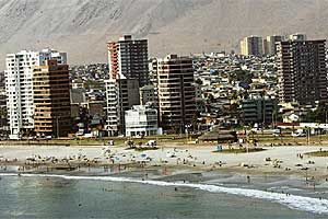
Extense coast
The coast of our country is formed by a series of plains and terraces developed between the Coastal Mountain Range and the sea. These are called littoral plains and their formation goes back to past geological epochs, when the waters of the Pacific Ocean reached a higher height and eroded continuously the western edge of the Coastal Mountain Ranges.
In the North Zone they arise, in a discontinuous form, due to the presence of the coastal cliff; nevertheless, this phenomenon disappears in the environs of Taltal, in the Antofagasta Region, from where true terraces are developed in an interrupted way until the Chacao Channel.
In them, important cities and ports are located, such as Arica, Iquique, Coquimbo, La Serena, Valparaiso, San Antonio, and Talcahuano, among others. Besides, it is a place of economic importance, as it possesses coal deposits.


 Muere Evita